Researching Green Infrastructure in Tropical Climates
Many communities are turning to rain barrels and rain gardens, permeable pavement, green roofs, and other green infrastructure practices to reduce the negative impacts of stormwater runoff. But can green infrastructure help in areas with consistent warm temperatures, daily rain, and the periodic deluge of tropical storms?
EPA researchers conducted a project in San Juan, Puerto Rico to find out.
The research team constructed a rain garden with environmental monitors and sensors to measure moisture absorption and storage on the Albert Einstein High School campus in the community of Caño Martin Pena . Preliminary results suggest that green infrastructure can be tailored to meet the demands of tropical climates.
Highlights of the Research
Potential for Green Infrastructure in Puerto Rico

Tropical climates can pose many design and performance challenges for green infrastructure installations such as rain gardens or green roofs due to the frequency, amount, and intensity of rainfall received. Green infrastructure design is primarily based on practices developed in the Mid-Atlantic, Northeast, and Pacific Northwest regions of the U.S., where the climates share similar moisture and temperature regimes. In addition, much of the existing research into the effectiveness of green infrastructure has been performed in these climates, so less is known about its performance in tropical climates.
EPA conducted a project aimed at designing, constructing, monitoring, and maintaining a green infrastructure system in the metropolitan area of San Juan, Puerto Rico, with the goal of successfully adopting green infrastructure technology elsewhere on the island. “Our partners in Puerto Rico are eager to adopt new and green technologies to improve their environment. Projects like this can lead to wider application of green infrastructure throughout the island and, hopefully, in other tropical areas as well,” says EPA environmental engineer Thomas O’Connor.
This project was performed in the community of Caño Martín Peña (CMP) in San Juan. The CMP community is adjacent to the Martín Peña Channel, a 3.75-mile long tidal channel located within Puerto Rico’s San Juan Bay National Estuary. Environmental issues in the channel, including reduced flow due to sediment build up, have led to frequent flooding in the CMP community. While the use of green infrastructure is primarily for water quality benefits, widespread use of green infrastructure throughout a watershed can reduce flood losses (EPA, 2015); incorporating green infrastructure into the landscape throughout the CMP community, especially upstream of the channel, can help mitigate the impacts of flooding.
Existing Green Infrastructure Design
Green infrastructure design is primarily based on practices developed in the Mid-Atlantic, Northeast, and Pacific Northwest regions of the U.S. While these locations are geographically diverse, the climates share similar moisture and temperature regimes; much of the existing green infrastructure research and monitoring has also been performed in this climate regime.
The climate of San Juan is classified as tropical monsoon climate (Köppen, 1936). Far less is known about green infrastructure performance in tropical climates than in other climates. Tropical climates have larger rainfall events, more days of measurable rainfall (greater than 3 millimeters), and uneven distribution of rainfall due to tropical storms. However, warmer tropical temperatures allow for greater uptake of stormwater by vegetation and associated potential for evapotranspiration. For example, compare the climates of Washington, DC and San Juan, Puerto Rico.
Rain Garden Approach

The research team constructed a 13.5 meter by 3.5 meter and 0.6 meter deep rain garden at the Albert Einstein High School in CMP. The composition of the rain garden from bottom up included a geotextile layer, a drainage layer of clean washed stone, amended soil mix, and a thick layer of mulch (76-100 millimeters). Additionally, 200 native plants, adapted to saturated conditions and well drained soils, were planted. Monitoring in the rain garden included pressure transducers, instruments that measure water pressure changes to provide data on stormwater infiltration into the soil. The pressure transducers were placed in piezometers (vertical pipes) at depths of 0.3 and 0.6 meters, and recorded data at 12-minute intervals.
Results
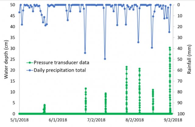
The graph below shows the 0.6 m deep pressure transducer response in the raingarden to storm events from May to August 2018 (NOAA 2019). In general, the rain garden shows measurable water depth for the 0.6m piezometer for events greater than 20 millimeters and does not show measurable water depth for smaller rain fall events, i.e., less than 10 millimeters. The maximum observed water depth was 30.3 centimeters, so prolonged surface ponding (greater than 60 centimeters) was not an issue. All observed drawdowns in the pressure transducer data lasted less than 12 hours, so the layers of stone and pea gravel adequately drained after storm events, as did the underlying subsoil.

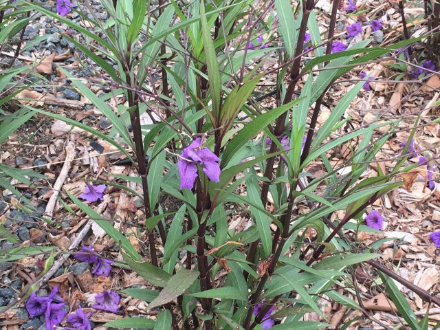
The vegetation required minimal maintenance. Most of the Britton’s wild petunia (Ruellia caerulea) and half of the wedelia (Sphagneticola trilobata) survived the initial six months. Surface mulching was an effective weed barrier, but mulch layer thickness may have limited rooting potential of wedelia plugs.
Impacts
Preliminary results from this installation indicate that properly designed and constructed rain gardens have the potential to help control stormwater in tropical climates.
Implementation of rain gardens and other green infrastructure techniques throughout Puerto Rico could provide adequate management of stormwater events at the local level. Widespread use of green infrastructure could also help reduce flooding impacts (EPA, 2015) and enhance protection of drinking water and recreational water resources.
References
EPA (2015) “Flood Loss Avoidance Benefits of Green Infrastructure for Stormwater Management,” Office of Wetlands, Oceans and Watersheds, Nonpoint Source Control Branch.
Köppen, W. (1936) Das geographische System der Klimate (PDF) . Handbuch der Klimatologie (ed. by W. Köppen and R. Geiger), Vol. 1 Part C pp. 1-44. Verlag von Gebrüder Borntraeger, Berlin.
NOAA (2019) U.S. Monthly Climate Normals (1981-2010).
Acknowledgement
This project was funded through EPA’s Regional Applied Research Effort (RARE) program, in partnership with EPA Region 2.
