EPA Expands Air Monitoring Capabilities to Support Wildfire-Impacted States, Tribes and Their Frontline Firefighters
Updated May 28, 2024; Published October 5, 2021

EPA is continuing to help communities monitor air quality during wildfires to protect the public from the health risks of smoke exposure. As part of this effort, EPA launched the Wildfire Smoke Air Monitoring Response Technology (WSMART) Pilot in 2021 to quickly get air quality information into the hands of air quality and public health officials during wildfires. Through the WSMART program, EPA loans air monitoring technologies to federal, state, local, and Tribal air quality professionals to support supplemental air monitoring in areas that experience wildfire smoke and with observational data coverage gaps.
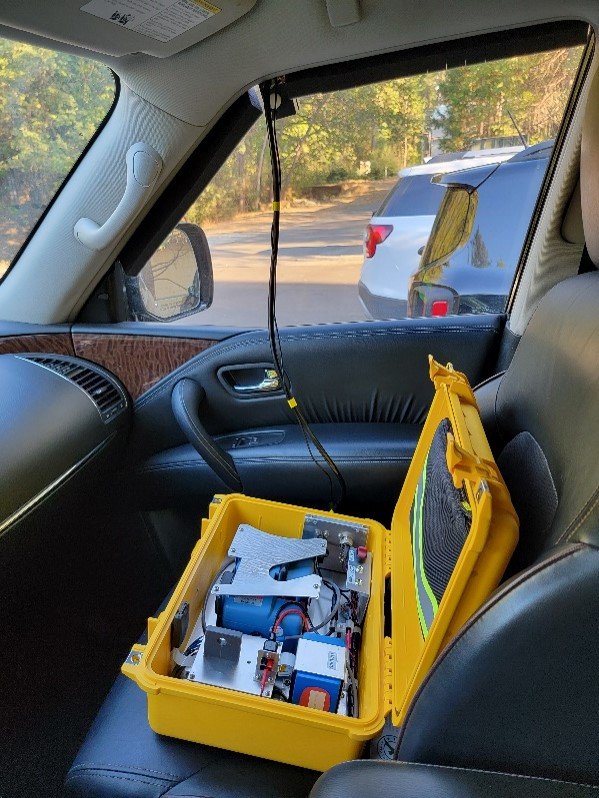
The types of air monitoring equipment EPA uses in this program include commercially available air sensor technologies and an EPA-developed mobile air monitoring system that enables an individual to map air quality while driving. These systems can be used to quickly provide supplemental data and enhance air quality information during wildfires, supporting firefighting personnel and smoke-impacted communities.
“Wildfire smoke impacts are often very dynamic and affect rural communities without a nearby air monitoring station,” said Bryan Hubbell, National Program Director of EPA’s Air, Climate, and Energy Research Program. “With over fifty loan recipients since it began, this program helps address the data gaps and put air quality agencies in a better position to assess smoke conditions and protect public health. We think it is very important to be able to provide on-the-ground air monitoring support for firefighting personnel to help protect them from hazardous air quality conditions in terrain that is hard to model.”
The loan project provides three different air measurement devices, all of which measure fine particulate matter (PM2.5), a major component of smoke, which causes serious health cardiovascular and respiratory health effects. One monitoring system, called the Vehicle Add-on Mobile Monitoring System (VAMMS), is a compact system that is custom-built by EPA to combine a PM2.5 instrument (Thermo Scientific pDR-1500), a carbon monoxide sensor, global positioning system (GPS), and ancillary equipment that can be attached to any vehicle to obtain mobile measurements. These measurements can be used to assess smoke exposure conditions in communities and rest areas for frontline firefighting personnel and provide data to compare against smoke forecasting models. The two air sensors, the PurpleAir PM2.5 sensor and Outpost Environmental Canary-X multi-pollutant sensor system, are commercial systems for stationary monitoring that can be quickly set up wherever needed.
EPA loans the air measurement devices upon request directly to state, local, and Tribal air organizations in areas affected by wildfire smoke. Those organizations will be able to make requests for use of the equipment through the WSMART page which can be found on EPA’s Air Sensor Toolbox.
EPA also loans monitors and sensors to the U.S. Forest Service-led Interagency Wildland Fire Air Quality Response Program for use by Air Resource Advisors (ARAs) who work with Incident Management Teams at major wildfires. ARAs are trained technical specialists who are dispatched nationally to assist wildfire incidents with smoke assessment using monitors and sensors, smoke forecasting, and communication on smoke conditions that affect the public and fire personnel. They also analyze and communicate smoke impacts to wildfire Incident Management Teams, air quality regulators, and the public. EPA currently has ten staff scientists trained as ARAs who plan to participate in the program during the 2024 wildfire year.
“The additional monitoring capability provided by the EPA is helping our Air Resource Advisors better understand smoke levels between existing monitoring sites and augmenting knowledge of smoke transport in complex terrain, which will lead to better Smoke Outlooks and improve messaging to the public on when they need to take protective measures to reduce their exposure to smoke,” said Pete Lahm, Air Resource Specialist at the U.S. Department of Agriculture Forest Service and Leader of the Interagency Wildland Fire Air Quality Response Team.
In 2021, EPA’s Ali Kamal used a VAMMS monitor while dispatched as an ARA to serve at the Monument and McFarland Fires in Northern California. After utilizing the VAMMS, he noted, “This not only helped with situational awareness of changes of smoke across the terrain, but also personal awareness to be able to be more conversant on smoke and ambient concentrations.” EPA ARA John Iiames had a similar experience using a VAMMS at the McKinney Fire in 2022 – read more about his deployment in EPA Science Matters. Deputy ARA Josh Hall and ARA trainee Amara Holder used the VAMMS at the Lookout Fire in 2023 to monitor outdoors and indoors to identify potentially hazardous smoke conditions in areas near the fire – read more about their experience in EPA Science Matters.
The goal of the WSMART program is to quickly respond and rapidly ship the shared equipment to the partnering organizations. If EPA receives requests for more equipment than is available, priority will go to smoke-impacted areas with gaps in monitoring data. Additional information on each type of measurement system is described below.

EPA’s Vehicle Add-on Mobile Monitoring System (VAMMS)
The VAMMS was developed by EPA scientists in 2019 and tested in the field to measure air quality during wildfires and smoke. It is a briefcase-sized unit that can measure ambient air from a vehicle. As the vehicle drives, a specially designed inlet mounted on the window continuously draws in a sample to measure PM2.5 on a second-by-second basis in addition to GPS coordinates. The VAMMS data is stored on a portable memory card in the unit. Users can transfer the data to a computer and use EPA’s Real Time Geospatial (RETIGO) data viewer to create a smoke map for the area.
The VAMMS is particularly useful in showing how smoke funnels into mountain valleys and surrounding areas. “This level of spatial resolution on the ground in these mountainous areas is just extraordinary,” said Amara Holder, an EPA researcher who led much of the development of VAMMS.
In 2023, EPA redesigned the VAMMS to add carbon monoxide monitoring capability, an important air pollutant to measure in first responder work or sleep areas located very close to fires. The newest generation VAMMS will be provided through the WSMART program.
PM2.5 Sensors and the AirNow Fire and Smoke Map
WSMART loans a widely used type of air sensor that continually measures PM2.5 and streams the data to a web platform. In 2020, EPA researchers developed a correction equation that improved the accuracy of reported data and refined the correction method for high concentration smoke events. This work made it possible to display the data from many of these sensors on the USDA Forest Service and EPA’s AirNow Fire and Smoke Map. The Fire and Smoke Map displays information on ground-level PM2.5 from smoke and other sources, as well as other information about wildfires and air quality. The map allows users to browse conditions at their current location or other locations of interest, see ARA developed Smoke Outlooks when available, and provides recommendations on when and how to reduce smoke exposure.
Multipollutant Air Sensor System
The Canary-X is a multipollutant sensor system that measures PM2.5, carbon monoxide, and total volatile organic carbon concentrations continuously in a compact package. In addition to PM2.5, carbon monoxide is of interest to understand wildland firefighter and other frontline worker exposure during heavy smoke conditions. The Canary-X system is solar powered and supports cellular data transmission so that air quality data can be obtained in areas with limited infrastructure and be viewed remotely.
EPA will work with organizations receiving loaned equipment to get the units to the right places, set up for data collection, and assist with any troubleshooting. After a wildfire event has concluded, EPA will work with federal, state, local and Tribal air agencies to retrieve the shared equipment so it can be shared with other air agencies.
DISCLAIMER
Any mention of trade names, manufacturers or products does not imply an endorsement by the United States Government or the U.S. Environmental Protection Agency. EPA and its employees do not endorse any commercial products, services, or enterprises.
Learn More:
- Wildfire Smoke Air Monitoring Response Technology (WSMART)
- Protect Yourself from Wildfire Smoke
- Smoke-Ready Toolbox for Wildfires
- AirNow Fire and Smoke Map
- Wildfire Smoke: A Guide for Public Health Officials
- Air Sensor Toolbox
- Wildland Fire Sensors Challenge: Winners Provide Real-time Systems for Measuring Pollutant Levels from Smoke
- Real Time Geospatial Data Viewer (RETIGO)
- Interagency Wildland Fire Air Quality Response Program (IWFAQRP)
