Climate Adaptation Profile: Solvents Recovery Service of New England, Inc. Superfund Site
Southington, Connecticut
Site Description
Past industrial activities at the Solvents Recovery Service of New England, Inc. Superfund Site entailed operating a hazardous waste treatment and storage facility and receiving waste industrial solvents. The processing sludge was disposed of in two unlined lagoons from 1957 until 1967, when the lagoons were drained and covered with fill. In later years, a portion of the waste was burned in an onsite open pit. The 42-acre site includes wetlands that border the Quinnipiac River as it flows to Long Island Sound.
Remediation Activities
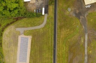
Initial activities involved removing drums containing contaminated material and constructing a groundwater pump and treat system. To address contamination in the site’s shallow aquifer, an in situ thermal heating system operated in 2014-2015. Current activities focus on maintaining a 2.9-acre multilayer cap installed in 2017 above contaminated soil and sediment, and continuing extraction of contaminated groundwater for ex situ treatment.
Vulnerability to Climate Change Impacts
Due its proximity to the Quinnipiac River, portions of the site are vulnerable to flooding and associated soil erosion during and after extreme weather events. In September 2021, for example, the remnants of Hurricane Ida deposited nearly six inches of rain in the Southington community over a period of several hours, which resulted in widespread flooding. The groundwater extraction wells are located within the 100-year floodplain.
Building Adaptive Capacity for Future Climate Scenarios
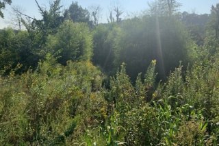
Design and construction of the remedy leveraged nature-based systems to simultaneously mitigate and adapt to climate change. Management of onsite stormwater, for example, relies on a combined green and gray infrastructure. During construction of the soil/sediment cap, a vegetated swale was installed along the cap’s perimeter to collect and disperse stormwater shed from the cap’s surface. A second vegetated swale was installed to collect runoff from impervious surfaces and built structures. The collected stormwater runoff flows to a constructed infiltration gallery capable of storing up to 1,600 cubic feet of water. In other upland areas, rock-lined channels were created to capture and carry stormwater by way of existing gradients to the site’s natural wetlands.
The tops of the site's two groundwater extraction wells are encased in concrete housings that prevent floodwater damage to the wellheads, pump, piping and other aboveground or at-grade components. The extraction wells' electrical controls are encased in a waterproof box installed on a concrete platform extending approximately one foot above ground surface. As a precaution, groundwater extraction is temporarily suspended when floodwater rises in the vicinity of the extraction wells. Hydrologic modeling indicates the suspension of the groundwater extraction system during flood conditions does not reduce resilience of the groundwater remedy due to the site's slow rate of contaminant migration.
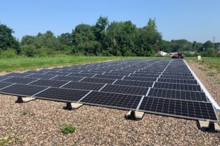
An onsite renewable energy system provides additional climate mitigation and adaptation synergies to the site by minimizing emission of greenhouse gas and providing energy resilience and diversification. In 2018, a 53 kilowatt photovoltaic array was installed above the completed soil/sediment cap to directly power the site’s four groundwater extraction pumps and a supporting building. Excess power generated by the solar array is transferred to the utility grid for electricity purchase credits. The credits are applied on cloudy days when the solar array cannot meet the full energy demand and grid-supplied electricity is needed for continued groundwater extraction.
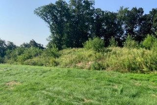
Highly mixed native vegetation across the site sequesters significant amounts of atmospheric carbon while enhancing infiltration and filtration of rainfall and snowmelt. During design of the soil/sediment cap, a plant survey was conducted to guide post-construction restoration of damaged vegetation. Approximately 600 native wetland trees and shrubs were planted in remediated wetlands and approximately 2,100 native trees and shrubs were planted in disturbed upland areas. Restoration of the natural forested wetland and upland areas is quantitatively monitored to generate data for calculating the percent ground cover and percent survival of planted trees and shrubs.
In addition to alleviating flooding along the Quinnipiac River, vegetation restoration is critical to long-term sustainability of the region’s ecosystems and ecosystem services. A habitat restoration project undertaken by the U.S. Fish and Wildlife Service and Connecticut Department of Energy Environmental Protection (DEEP) in 2013 focuses on assuring long-term sustainability and resilience of nearly two acres of wetland, including a portion of the Quinnipiac River, impacted by the site’s past industrial activities. The majority of the site is anticipated to be reserved as greenspace.
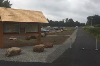
Additional green/gray infrastructure for onsite stormwater management was emplaced in an onsite area now hosting a recreational greenway. Integrated planning of site remediation and reuse enabled a strip above the site’s soil/sediment cap to be paved for use as a pathway extending to the regional Farmington Canal Heritage Trail, which spans more than 80 miles between Northampton, Massachusetts and New Haven, Connecticut. Vegetated swales along the recreational pathway and an onsite parking lot filter localized runoff and prevent associated erosion. A concrete level spreader and vegetated filter strip on the downgradient side of the parking lot work together to further manage stormwater.
Superfund Climate Resilience
EPA provides additional information about approaches for building climate resilience at Superfund sites.
Overview of Implemented Climate Resilience Measures
The site’s responsible parties collaborated with the Connecticut DEEP and U.S. EPA to incorporate measures during design, construction and long-term monitoring of the remedy:
- Constructed an infiltration gallery storing up to 1,500 cubic feet of water.
- Installed vegetated swales that infiltrate, filter and convey stormwater.
- Re-established contiguous swaths of mixed native vegetation in wetlands and upland areas.
- Conducting long-term monitoring of plant communities and re-planting or re-seeding as needed.
- Encased the tops of groundwater extraction wells in concrete housings.
- Encased electrical controls for groundwater extraction wells in elevated waterproof boxes.
- Using onsite renewable energy to power remediation equipment.
Key Tools for Climate Projections
- Connecticut DEEP Geographic Information Systems
- Updates to the Existing MODFLOW Groundwater Flow Model, ARCADIS U.S., Inc., January 2011
- Feasibility Study: Solvents Recovery Service of New England, Inc. Superfund Site, U.S. EPA Region 1 and Blasland, Bouck & Lee, Inc., May 2005
Points of Contact
- Kevin Heine, U.S. EPA Region 1
- Shannon Pociu, Connecticut Department of Energy and Environmental Protection
References
- Restoration Plan and Environmental Assessment: Old Southington Landfill Superfund Site, Southington, Connecticut, and Solvents Recovery Service Superfund Site, Southington Connecticut, October 2013, U.S. Department of the Interior, U.S. Fish and Wildlife Service
- RCRA Cap 100% Design Report, Solvents Recovery Service of New England, Inc. (SRSNE) Superfund Site, October 2016, SRSNE Site Group
- Third Five-Year Review Report for Solvents Recovery Service of New England, Inc. Superfund Site, September 2020, U.S. EPA Region 1
- Green Remediation Profile: Solvents Recovery Service of New England, Inc. Superfund Site, September 2021, U.S. EPA
July 2022
