EPA Research in Florida’s Pensacola and Perdido Bays
- Studying tire-derived pollutants in stormwater
- Conducting hydrodynamic & water quality modeling study
- Assisting with National Coastal Condition Assessment intensification survey
- Evaluating effectiveness of fecal indicator test methods in marine, estuarine & freshwater systems
- Using Environmental DNA methods to learn about aquatic species & habitats
- Evaluating community vulnerability & resilience in Florida watersheds
- Using periodic counts to estimate coastal estuary recreational use
EPA scientists partner with Florida’s Escambia County to study tire-derived pollutants in stormwater
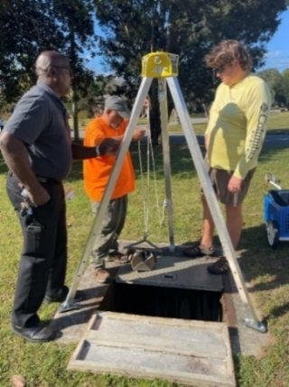
Every time you drive a car, your tires shed tiny particles of plastic and other pollutants from contact with the road. When it rains, these particles are washed away. But where do they go, how do they get there, and what can be done about it? In Pensacola Bay, Fla., EPA researchers are working to find out.
During spring 2023, EPA scientists began investigating how these particles and pollutants travel from the source, like a roadway, through stormwater retention ponds and into tidal (estuarine) ecosystems depending on traffic, weather conditions, and filtration systems.
Tire particles and associated pollutants include heavy metals, microplastics, and chemicals such as 6-PPD quinone, which is highly toxic to many species of game fish. Researchers want to determine if current stormwater management features like bioswales and retention ponds are effective in reducing environmental damage from these pollutants. Study results will help design better stormwater treatment facilities and create healthier natural environments in surrounding communities. This research is being conducted in collaboration with Escambia County, Fla.
EPA scientists and partners conduct hydrodynamic and water quality modeling study in Florida’s Pensacola Bay
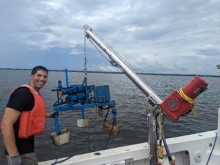
EPA researchers are conducting a hydrodynamic and water quality modeling project in Pensacola Bay, Fla. between 2022-2026. The project measures and maps water quality (called spatial surveys) and collects information over a certain time period (high frequency time-series data) about dissolved oxygen, pH, and other water quality variables at select sites that are vulnerable to low oxygen and acidification. These data show how often low oxygen (hypoxia) and reduced pH conditions happen, how long they last, and where they are located in Pensacola Bay. Study results will help improve water quality simulation models used for estuaries at risk from human activities and global climate change. The information will also help scientists better understand what physical conditions and biological controls change oxygen and pH levels in water, as well as the impact of human activities on water quality throughout the estuary.
Key Project Goals:
- Develop high-resolution hydrodynamic and water quality model of Pensacola Bay.
- Examine how low dissolved oxygen events change based on seasonal environmental drivers and reduced nutrient loads.
- Improve model application to evaluate cumulative stressors of low dissolved oxygen and low pH (acidification).
- Simulate hydrodynamic and water quality response to future climate change conditions and proposed nutrient management actions.
This research is being conducted in collaboration with the Pensacola & Perdido Bays Estuary Program.
EPA scientists assist with National Coastal Condition Assessment intensification survey in Florida’s Pensacola and Perdido Bays
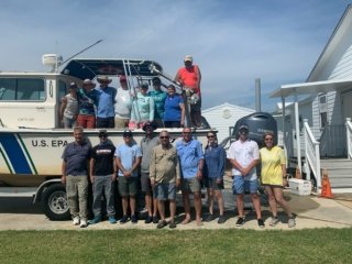
When Florida’s Pensacola & Perdido Bays Estuary Program (PPBEP) began a long-term environmental monitoring program in 2021, EPA researchers helped them develop and use an environmental monitoring strategy called probabilistic sampling. Probabilistic sampling uses statistics to determine where scientists decide to sample. Sites are randomly chosen and spatially balanced based on the area of interest or target population. Using protocols established under EPA’s National Coastal Condition Assessment (NCCA), scientists collected water, sediment, and fish samples and measurements and analyzed them for pollutants, toxicity, and biological characteristics. EPA staff also provided technical support for survey design, training, field logistics, and sample collection. PPBEP uses the sampling results as a baseline as they monitor progress in restoring and maintaining the resilience of Pensacola and Perdido Bays and the benefits local communities gain from healthy estuaries. This research was conducted in collaboration with Escambia County, Fla. and the Florida Fish and Wildlife Conservation Commission.
EPA scientists evaluate effectiveness of fecal indicator test methods in marine, estuarine, and freshwater systems
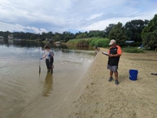
One of EPA’s responsibilities is to develop standards to protect people from harmful organisms like viruses and bacteria, in lakes, rivers, beaches and other waterbodies. Swimming and other recreational activities in contaminated water can make people ill.
EPA recommends numerical limits for certain organisms and their associated toxins in water bodies to protect human health. State and tribal governments can use these criteria as guidance when setting their own water quality standards.
But how do you know when your water is contaminated? To find out, scientists test water for certain bacteria that usually live in human and animal gastrointestinal tracts. These are called fecal indicator bacteria and their presence signifies a sewage or runoff impact to nearby waters. Molecular tools, such as Polymerase Chain Reaction (PCR), are used to detect and identify fecal indicators. Bacteria and viruses are often host-specific, and molecular tools such as PCR can also tell researchers if sewage is from human, bird, or other animal sources. From spring of 2021 until summer 2022, EPA researchers sampled three sites with different salinity levels (marine, estuarine and freshwater) in the Pensacola Bay, Fla., watershed to evaluate which test methods were best and to estimate if any of the fecal indicators were affected by different salinities. Once a week, researchers collected water from each site and took water- quality measurements. Back in the lab, EPA researchers combined water samples by site and analyzed them for fecal indicator bacteria (E. coli and enterococci) and coliphages (specific viruses found in human feces). They also filtered and froze the prepared water samples to extract DNA for additional PCR tests to determine the occurrence of host-associated genetic markers, such as human, dog or bird.
Results from this study will help determine which test methods best support EPA’s Recreational Water Quality Criteria and Coliphage Criteria with the intent of providing tools that can be used by federal, regional, and state laboratories and tribes to assess fecal-impacted watersheds.
EPA scientists use Environmental DNA methods to learn about aquatic species and habitats in Florida’s Pensacola & Perdido Bays
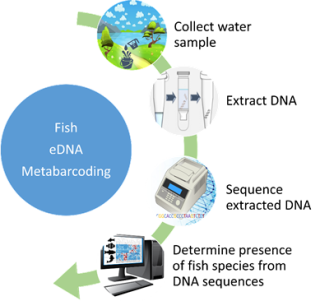
What kinds of fish and other animals live on the sea floor in Florida’s Pensacola and Perdido Bays? EPA is conducting two studies that use environmental DNA (eDNA) to find out.
Living organisms constantly shed and excrete DNA into the environment. This eDNA can be easily collected from water or sediment samples and used to identify organisms that live in or periodically visit our waters. This process is called eDNA metabarcoding, and is a low effort, lesser impact, and more accurate way to identify fish and invertebrate species in specific locations. It’s substantially faster than trying to collect or count every single organism. Also, this method can detect species that are rarely seen, such as threatened and endangered species, or unexpected, such as invasive species.
This research will help determine if eDNA metabarcoding is a useful tool to describe fish and invertebrate diversity in estuaries; help establish when, where, and how many organisms are found; and help create a DNA library for the local area. This research is being conducted in collaboration with Pensacola & Perdido Bays Estuary Program and The Nature Conservancy.
Learn More
EPA scientists evaluate community vulnerability and resilience in Florida watersheds
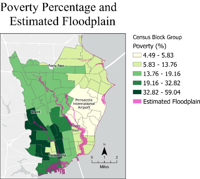
EPA scientists have developed methods and models to evaluate local access and vulnerability measures within Florida’s Pensacola and Perdido Bay watersheds. Local access includes parks, grocery stores, medical facilities, museums, libraries, and other community amenities that would improve well-being through social, cultural, or recreational activities. Vulnerabilities are potential hazards-either natural, like hurricanes, tornados, and floods- or technological, like superfund sites or facilities that emit hazardous air or water pollution.
This project, started in spring 2020 in the Carpenter's Creek Watershed of Pensacola Bay, helps determine community vulnerability and resilience as part of a Comprehensive Conservation and Management Plan (CCMP). The models use access distance calculations (time) modified with community infrastructure (available roadways, public transit, walking paths/sidewalks, etc.). Vulnerabilities are calculated using historical occurrence overlays with community and recurrence rates.
Researchers created a framework of multiple datasets at the local level to assess baseline community characteristics, including social characteristics (community attachment, education level, feeling of support, health), economic characteristics (home values, poverty rates, percent of income spent on housing), and physical characteristics such as housing conditions. Infrastructure data incorporate roadways and their conditions, public transit, utility types and locations, and communication infrastructure. The built and natural environment category includes assessments of location and condition of each entity within the community.
This information can help communities make better decisions about local resilience and sustainability. Researchers also completed geospatial analyses to assess individual, family, and housing vulnerabilities in conjunction with flood susceptibilities for census block groups within the Pensacola and Perdido Bay Watersheds. The initial geospatial models combine drivetime analyses, which find the shortest drive from every residential building to every amenity in the watershed. Researchers then create groups like recreation, education, and health care and can combine the parcel data (households) up to any level (i.e., census tracts, block groups, watersheds) needed to help make decisions.
Hazard overlays, based on previous research, use a spatial multi-hazard model to calculate intersections of the population with all hazards. For example, a hurricane path is buffered to show where wind and storm surge would exist. Where this area intersects with the community is considered a risk.
Researchers create proportional exposure values for each area and combine them for a total exposure score, including population vulnerability characteristics like lack of information, limited roadways for evacuation, and other socioeconomic factors. Areas with high exposure and high vulnerabilities are highlighted as the most critical locations for further analysis/actions.
Results from these analyses are included in the Pensacola & Perdido Bays Estuary Program (PPBEP) Comprehensive Conservation and Management Plan (CCMP) to help outline and meet objectives for assessing social vulnerabilities of communities under a changing climate. This research was conducted in collaboration with the Pensacola and Perdido Bays Estuary Program and Escambia County, Fla.
EPA scientists use periodic counts to estimate coastal estuary recreational use
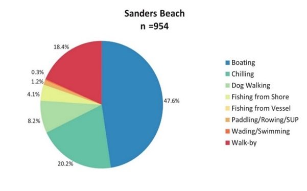
How are parks used by the public they’re meant to serve? One way to find out is to count how many people are using them.
In 2022, EPA researchers observed visitors at two sites, Sanders Beach and Bayview Park in Pensacola, Fla., to learn more about coastal estuary recreational use in northwest Florida. The observational surveys aimed to test the transferability of a method for using periodic counts to estimate public recreational use. The sites were also part of EPA sanitary surveys, which examine water quality but also count the number of people using the area at the time. Sanitary surveys at beaches and the surrounding watershed involve investigating sources of fecal contamination. The surveys help state and local program managers and public health officials identify sources of water pollution, assess its severity, and prioritize locations for water testing.
Having both results at the same sites helps demonstrate the usefulness of using EPA sanitary surveys to estimate broader recreational use. Each observational survey recorded the number of people using a beach or park space during a given time and their activities such as boating, walking, fishing, and more. The combined observational surveys and counts from sanitary surveys will be examined to document when the parks are used during the day and at what time of year. This information will help EPA quantify how important water quality is to people and possible benefits of improving and protecting coastal water quality. This research was conducted in collaboration with Pensacola and Perdido Bays Estuary Program.
